Why were you awarded the Innovationspriset 2019?
I am developing a modelling system called WISE-FASS (Wildfire Spread Estimator and Fire Attack Support System). The system is being developed for the emergency services and constitutes a forecasting tool for wildfire spread in Sweden.
How does the model work?
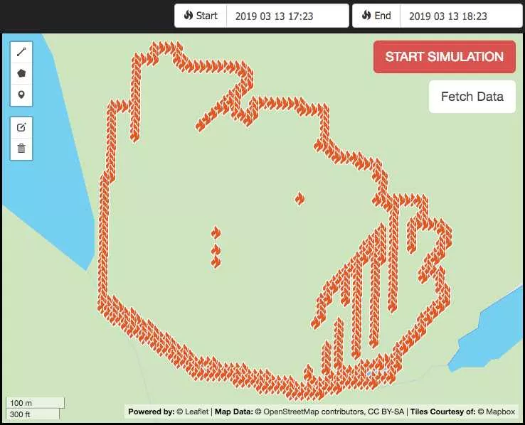
Topographic, ground cover and weather information is automatically downloaded from authorities. The system preprocesses this information (i.e. by performing GIS operations) before it is fed into the model. This is what makes WISE-FASS unique - the large amount of input data needed for a simulation is automatically pre-processed allowing a simulation when it is needed. It means that forecasts of fire spread, during the first hours, are available within seconds - before the emergency services have left the fire station (view image further down).
Is it applicable all over Sweden?
Yes, support for Swedish vegetation types are supported by the system but it requires correctly classified ground cover data. Fire spread in arable lands may be difficult to simulate as crops varies between years. Crops are not fully classified as fuel types. A fuel type is basically an instruction of how fire behaves in a specific vegetation type. Authorities are currently developing a fuel type classification of Swedish vegetation.
How come you work with wildfire modelling?
I am a trained firefighter and I have wanted to work with natural disasters since many years. It is actually storms that I aim to work with. However, in a sense I think I already do so as persons located in the middle of a wildfire probably find their lives to be stormy.
Do you think the system will be used by the emergency services within 5 years?
Yes, I hope to have a finished product in two years from now. When and how the system will be implemented in the society greatly depends on decisions by the authorities, especially MSB (Swedish Civil Contingencies Agency).
Are you the only one developing the system?
Yes, I am alone working on WISE-FASS. It has been a spare time project since about two years but the actual programming started last summer when I received a Leapfrog scholarship. It was three months filled with action. The project is, to some extent, based on the BSc thesis I wrote together with a fellow student at this the department of Physical Geography. It is an evaluation of whether two existing fire growth models were suitable for use in Sweden. I held a seminar during a workshop by SMHI in October 2018 where several authorities were present. Since then, there has been a great interest from e.g. SMHI (Swedish Meteorological and Hydrological Institute) and MSB regarding the progress of the project.
Is physical geography a good field to study if someone wants to work with natural disasters?
It depends on how you plan to work but I would say yes, it is. When studying physical geography you learn about how the many processes in nature interacts between the spheres. During my firefighter training I learned a lot about disaster management but I do not find that as a necessity for working with natural disasters. Imagination and persistency will get you far.
Was your choice of studies a strategic decision or did you just follow your interests?
Actually, when graduating from the Upper Secondary School I did not want to continue studying. Now I am sitting here with just over seven years of education, partly as a firefighter and partly within physical geography and GIS. My choice to study physical geography was a bit of a chance. About 10 years ago I joined my cousin at an event here at LU and grabbed a booklet. A couple of years later, the booklet showed up and I realised it could be a suitable program for me.
What does winning the award mean to you?
The recognition is a proof that others, including people within the business world, believe in the project, a slight financial support and, most importantly, that I made a lot of contacts. Then it is of course cool with a diploma for the display rack…
Do you have any tips for students about what to do with their ideas?
Get in touch with LU Innovation. They help students and employees to get going with their ideas. Then you can apply for the Leapfrogs scholarship. It allows you to work on your idea for three months. The only obligations are to work full time with the idea and to participate in workshops.
Do you collaborate with scientists?
No, not yet but I am open for collaborations. However I am discussing opportunities with researcher Veiko Lehsten including the possibility of a PhD position. My current focus of the project is on the emergency services meaning WISE-FASS estimates wildfire spread but if coupling it to other models allows computation of for example release of green house gases during combustion. Scientists and students, interested in more information are welcomed to contact me, Susanna Olsson has the contact information.