Monitoring forest disturbance

With a changing climate there is an increasing risk of more frequent and severe disturbance events causing damage to our forests. These disturbances can be events such as storms, insect attacks or forest fires and they can affect the carbon balance as well as the economy. Hence, it is important to develop methods to monitor disturbances. Lund Earth Observation group is focusing on methods to monitor damage caused by insects, but the methods can be applied to all sorts of disturbances.
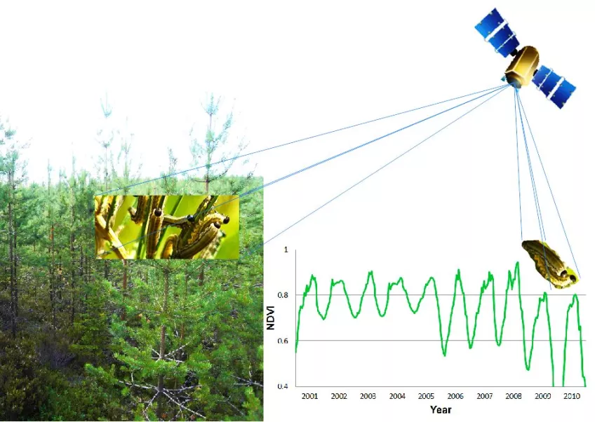
Insect attacks are dynamic events with a gradual defoliation that could last for longer periods. An area may be infested by insects for several years with both the amount of defoliation and the spatial distribution changing from year to year. It is possible to apply traditional change detection methods for insect attacks, both to find damaged areas and to estimate the amount of damage, but our focus is on time series analysis of frequently obtained satellite images since it enables monitoring of the dynamics in an attack.
Satellite images with high temporal resolution, such as MODIS, make it is possible to estimate the state of the vegetation in a forest with weekly or bi-weekly intervals. The development of the vegetation can be studied during entire growing seasons for years without disturbances to identify the normal seasonal development of a forest. By comparing the normal seasonal development to present year's development, deviations can be identified. Disturbance monitoring can then be based on a set of rules, defining when a deviation is large enough to be considered a disturbance. If these rules are well designed, it is possible to monitor how defoliation is increasing during an attack and how the attack is spreading in time and space. High temporal resolution satellite data also enables near real-time monitoring which makes it possible to detect disturbances in an early stage and to develop early warning systems. We have used these methodologies to study attacks of a new invasive insect in S. Sweden. We have also developed methods for near real-time monitoring of birch moth outbreaks in subarctic birch forest in Abisko in northern Sweden (see animation above) and to estimate the impact of these birch moth outbreaks on GPP.
References
Olsson, P.O., Heliasz, M., Jin, H., & Eklundh, L. (2017). Mapping the reduction in gross primary productivity in subarctic birch forests due to insect outbreaks. Biogeosciences, 14, 1703-1719
Olsson, P.-O., Lindström, J., & Eklundh, L. (2016). Near real-time monitoring of insect induced defoliation in subalpine birch forests with MODIS derived NDVI. Remote Sensing of Environment, 181, 42-53
Olsson, P.-O., Kantola, T., Lyytikäinen-Saarenmaa, P., Jönsson, A., & Eklundh, L. (2016). Development of a method for monitoring of insect induced forest defoliation – limitation of MODIS data in Fennoscandian forest landscapes.
Olsson, P.-O., Jönsson, A.M., & Eklundh, L. (2012). A new invasive insect in Sweden – Physokermes inopinatus: Tracing forest damage with satellite based remote sensing. Forest Ecology and Management, 285, 29-37
Contact information
Lars Eklundh
lars [dot] eklundh [at] nateko [dot] lu [dot] se
Phone: +46462229655